Am I a Geodesist?
Motivated by one of UNAVCO’s videos entitled, “Do You Call Yourself A Geodesist?” I began to wonder, am I a Geodesist?
Who is a Geodesist?
A geodesist measures the Earth’s surface as well as studies the science and shape of the planet and gravitational field. Measurements are taken of the size of Earth on a global and regional scale. By taking these measurements of the Earth, crustal shifts and polar movement can be detected. Measurements can determine rate of movement and other pertinent information. A geodesist assigns 3 dimensional points on, above and below the surface of Earth to measure the average depths of oceans, mountain peaks and also abnormalities in the surface of Earth.
Different core fields of Geodesy:
Mathematical : relates to three dimensional geometrical elements of the mathematical model of the earth.
Physical : relates to the geophysical internal constitution of the earth to the corresponding gravity field and its observable effects.
Satellite : deals with satellite orbits, tracks existing satellites, and predicts the trajectory of a given missile, satellite, or spacecraft.
Astronomy : chronicles the changing position of stars and other celestial objects. Although listed separately, it overlaps other areas of geodesy and will not be pursued separately here.
Relationship with Geodesy and other fields:
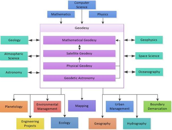
Components of the flowchart were adopted from, Vanicek, Petr, and Edward J. Krakiwsky. Geodesy: the concepts. Elsevier, 2013.
Garrett Seepersad
Enabling access to affordable high precision positioning and navigation.
GNSS measurement processing specialist (aka PPP and RTK positioning).